Map claims / Forgotten cities & lands beyond
Who put that
world on
the map?
Extra continents. Hidden civilizations. Forgotten cities. The first investigation is not where they are—it is who created the map, what they claimed, and what evidence traveled with it.
Claim-bearing artifact / Modern worldbuilding
“The World Beyond
the Ice Wall 3.0”
CREATOR: OHAWHEWHE / FICTIONAL PROJECTWhat the claim sounds like.
When maps of additional lands circulate without their creator’s description, they can be presented as charts of real concealed territories and civilizations beyond Antarctica.
What the source establishes.
This particular work belongs to a modern collaborative worldbuilding project. It is not an authenticated ancient map or an expedition survey. Read it with its creator’s description intact.
Why is this still worth exploring?
Because it shows how an elaborate visual narrative can travel into a different context. The art can be imaginative and absorbing without becoming geographic evidence. Follow the labels, authorship, and posting history before deciding what the map supports.
Two more provenance trails / Modern works
Do not merge
different maps into one story.
TERRA INFINITA / CLAUDIO NOCELLIA creator’s own modern map.
The original map is sold by Claudio Nocelli. A related book is catalogued as fiction. That is relevant provenance, but it is not a basis for claiming the creator has disavowed every belief associated with the work.
Question to carry forward: What independent observation supports a named location outside the creator’s map and narrative?
Original creator’s map page ↗
Related book catalog record ↗
Copyrighted modern map: linked, not reproduced. No purchase is required by this site.
SIXTY DEGREES SOUTH / NOVEL WORLDBUILDINGA historical date inside a story.
The maps page describes a “1950 Noonan map” in the story, while explaining that the maps were created by Andy while writing the novel. An in-universe date does not turn a modern story artifact into a verified 1950 chart.
Question to carry forward: Does a repost preserve the author’s explanation—or strip it away and relabel the image as a discovery?
Read the author’s maps page ↗
Modern copyrighted artwork: linked, not reproduced.
Historical advocacy / A separate category
An old claim is still
a claim you can test.
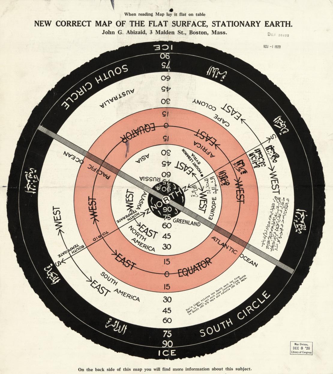
LIBRARY OF CONGRESS / ABIZAID / CIRCA 1920“New correct map of the flat surface, stationary earth.”
This genuine historical artifact documents an alternative-Earth argument. Its age and archive provenance establish the publication’s existence, not the physical accuracy of its model.
Keep the distinction visible
It is not the same category as modern fantasy worldbuilding. It is also not evidence that every named or imagined territory in later maps was surveyed.
Read the original record and inspect both sides ↗
John George Abizaid / Library of Congress, Geography and Map Division. Original artifact, not AI imagery.
An Atlantis map is an artifact about a claimed or imagined place—not independent confirmation that it existed where depicted. Each work needs its own author, date, purpose, and evidence trail.
Community claim / A name on a real map
“Tartaria” on the page.
What follows from the label?
FORUM ARGUMENT / NOT A VERIFIED EMPIREFollow the actual conversation.
A post in r/Tartaria presents a map as significant; a commenter links a Library of Congress map record. Those are separate artifacts: the post’s photograph should not be silently treated as the same map as the commenter’s link.
Read the original public discussion ↗
Productive next question: what city, date, architectural feature, or archival record is being claimed—and what independent source corroborates it? A geographical name and a lost-empire narrative are not the same finding.
A city-level claim needs city-level evidence
Bring a name.
Bring the original.
01 / LOCATEIdentify the actual label.
Capture the exact city or region name, original map title, author, date, and an uncropped view. Do not invent coordinates for a fantasy map.
02 / TRACERecover the map’s purpose.
Is it an expedition chart, religious cosmology, political advocacy, literary setting, or collaborative worldbuilding? A cropped image may hide the answer.
03 / CORROBORATELook outside the map.
What independent survey, archaeological record, material evidence, or documented observation supports the place? Reposts of the same image are not independent confirmation.
No forgotten Antarctic city is authenticated on this page. The invitation is to investigate specific claims carefully, not to substitute a compelling picture for a documented discovery.