Compare what mapmakers actually drew—not a modern overlay that quietly forces their coastlines to fit. Explore cleared scans here, and open institutional viewers where image reuse is restricted or unresolved.
UNREGISTERED VISUAL COMPARISON Independent scales, projections and purposes. No shared coordinate system.Six audited map records · two additional comparison contexts One of the six has a cleared local reproduction; five remain institutional-viewer links.
Two originals. No forced alignment.
INDEPENDENT PAN / ZOOM / SOURCE CHECK
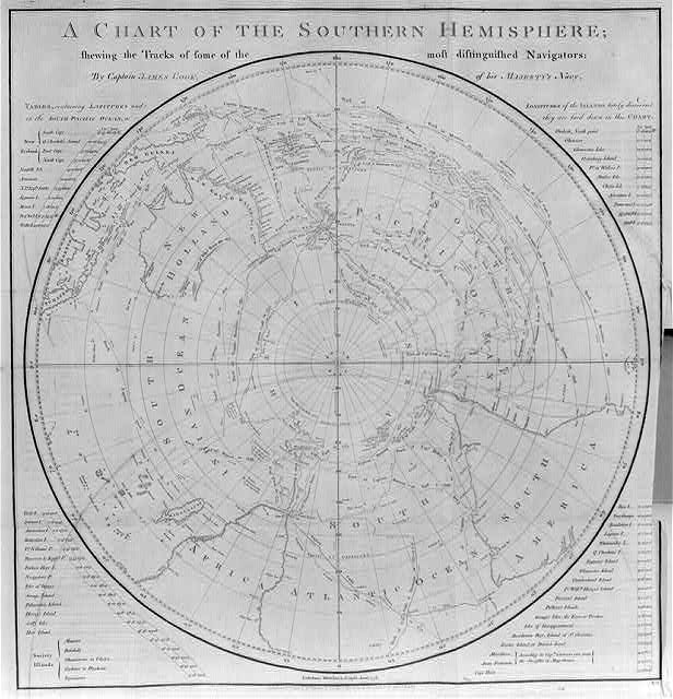
Cook: A chart of the Southern Hemisphere
LOC black-and-white film-copy reproduction, 616 × 640 pixels. Web-resolution scan: zoom cannot reveal detail absent from this file.
Drag to pan · focus an image before using the scroll wheel to zoom · pinch on touch · + / − zoom · arrow keys pan · Home fits. “Native pixels” restores available image detail; magnification cannot recover missing source resolution.
Correct source. Correct edition.
The six-map audit.
Dates distinguish a design or plate from the specific impression shown. Link-only cards do not download or embed restricted scans.
1513
Piri Reis world map fragment
Revan Köşkü Collection no.1633
The official nomination describes Brazil joined to a southern landmass seemingly representing hypothetical Terra Australis. This authentic artifact alone does not establish the later ice-free Queen Maud Land interpretation.
Artifact provenance is distinct from modern interpretation; no inference of secrecy or concealment from speculative geography or present-day web errors.
1597 plate;1611 scanned impression
Chica sive Patagonica et Australis Terra
11622.013
1597 map design in a 1611 French-volume impression. Two sections show Patagonia/the Strait of Magellan and a hypothetical southern continent; it is not exclusively a map of that continent and is not a modern survey.
Two sections depict the Strait of Magellan/Patagonia and a south-polar Terra Australis including Southern Africa and Madagascar.
Rumsey permits publication with attribution, and links CC BY-NC-SA3.0; source-specific Download1 exists. Do not describe reuse as unrestricted without qualification.
Artifact provenance is distinct from modern interpretation; no inference of secrecy or concealment from speculative geography or present-day web errors.
1531 design/signature; [1532] verified impression
Oronce Fine: Nova et integra universi orbis descriptio
GE D-6440 (RES); FRBNF40699514
A globe-to-plane projection containing an imagined southern landmass; neither heart shape nor latitude grid proves an ice-free Antarctic survey.
Conflated two maps. DD2987(63) is the single-heart Recens et integra orbis descriptio, dated1534–1536 in BnF exhibition. The double-heart map is signed July1531; this verified BnF impression is published[1532], GE D-6440(RES). Supplied ARK returned403 and remains unidentified, not proven invalid.
Specific Gallica reuse terms not audited; underlying historical work is old, but do not infer blanket scan reuse permission. External link only.
Artifact provenance is distinct from modern interpretation; no inference of secrecy or concealment from speculative geography or present-day web errors.
1570
Ortelius: Typus Orbis Terrarum
Rumsey10000.011
Terra Australis nondum cognita is a hypothetical southern continent, not evidence that the mapmaker surveyed Antarctica.
1570 work verified, but supplied3878.001 not verified. Correct source-specific Rumsey record is10000.011. Do not silently reuse the1598 vault image as1570.
Current policy permits attributed publication; also links CC BY-NC-SA3.0. Download1 present. Not unrestrictedPD wording.
Artifact provenance is distinct from modern interpretation; no inference of secrecy or concealment from speculative geography or present-day web errors.
1754 map; atlas publication1770?
Buache: Terres Australes
Rumsey5698.002
The map depicts conjectural polar lands separated by water. A central sea is an observable feature of this map, not proof of accurate ice-free/subglacial Antarctic geography.
0764.000 is1893 RandMcNally atlas, not Buache. Correct Rumsey5698.002 is dated1754, held in an atlas dated1770?.1739 in its title refers to Bouvet discoveries. A separate1739Buache artifact is cataloged by BnF; do not merge editions.
Rumsey current attributed-publication policy applies with stated exceptions and linkedCC terms; Newberry alternative record marks No Copyright-US and open access but warns metadata not fully processed.
Artifact provenance is distinct from modern interpretation; no inference of secrecy or concealment from speculative geography or present-day web errors.
1777 publication;1776 engraving
Cook: A chart of the Southern Hemisphere
LOC2002699851; Rumsey3404.002
Cook’s voyages undermined expectations of a vast temperate southern continent, without establishing Antarctica’s complete coastline or interior.
Chart verified independently: engraved1776, published1February1777. Supplied NLA identifier remains unresolved; do not claim it matched.71°10S supported by NLA guide. Avoid claim that one voyage proved complete polar geography.
LOC: No known restrictions on publication. This reproduction is a black-and-white film-copy scan, not a new color original.
Artifact provenance is distinct from modern interpretation; no inference of secrecy or concealment from speculative geography or present-day web errors.
It can reveal labels, coastline drawings, projection choices and documented changes between publications.
It cannot establish geographic accuracy merely because two shapes appear similar at a chosen scale or rotation.
No control points, georeferencing, synchronized geographic zoom, or reconstructed “hidden” coordinates have been applied.
Authentication, reuse permission and interpretation are separate questions. A genuine historical artifact does not by itself verify an ice-free Antarctic survey.